The west dunes formed about 120 years ago and are ‘mature’ with sycamore, ash, poplar, elm towards the north and hawthorn and elder towards the south: Clematis vitalba is now covering large areas. The top of the dune ridge meets resident’s gardens, which contain some of the more mature trees and garden rubbish, dumped over many years, has produced large areas of non native plants such as russian vine and snowberry. The eastern edge is predominantly sea buckthorn. There is a wide variety of other plants shrubs and grasses the most eye catching being pyramidal orchid, great mullein, rosebay willowherb and evening primrose.
A good variety of birds nest in these wooded areas and the cover is used by migrating birds, particularly when the easterly winds are strong.
In 2015 a large swathe of Buckthorn and scrub was removed from the eastern edge of the dunes between Drake Road and Buckthorn Avenue and a further section as far north as Derby Avenue in 2017, significantly reducing this valuable wildlife corridor by more than 50% in some places.
Central Dunes
There are a number of dunes towards the centre of the
marsh, which until 2015 were predominantly covered in
sea buckthorn, elder and dog rose. A large section of
these dunes had been cleared of sea buckthorn by
Dave Miller and his team of Volunteers in the hope of
re-establishing wider diversity of cover.
All these dunes have now had the scrub cover dragged out
by a mechanical digger, destabilising the sand and totally
destroying the delicate understory of native flora.
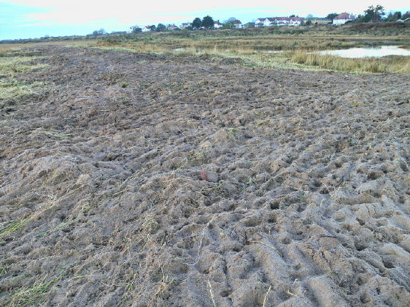
The photo to the right shows what remains of the dune so
carefully cleared by the many volunteers dedicating their
time and enthusiasm to the project. What a terrible waste
of this effort.
By 2024 there has been regrowth but the valuable ground cover of moss etc has yet to re-establish.
Outer Dunes
These outer dune ridges formed over the last 50/60 years and are eroding from the northern end and forming and spreading slowly seawards towards the south, where the leading edge of marram has progressed some 50 meters in the last 17 years. The outer ridge was first breached by the sea, just south of the old boat compound in September 2001, thought to have been caused by the introduction of ‘rock armour’ on Lagoon Walk and hastened by unauthorised access of the Beach Ferry across the dune ridge. [ to see a diagram of erosion CLICK ] Since 2010 embryo dunes have been forming to the south of the old boat compound and a dune ridge was re-establishing but much further to the west.
Following the destruction of the Buckthorn habitats by East Lindsey District Council contractors the erosion of the destabilised dunes has accelerated to such an extent that very shortly, spring tides will no longer be held back allowing regular flooding of the marsh and completely changing the character of the various habitats.
Plants that have made a visual impact in the past are sea-holly, pyramidal orchid, hay rattle and ragwort and we must wait and see what re-establishes.
For the past 10 years the valuable nesting and feeding sites have been lost and the vital cover for mammals away from residential properties has no longer been there. Although regrowth has happened, the richness of of the biodiversity has failed to reach its previous level and it is tragic that most of it will now be completely lost, having destabilised the protective dunes.
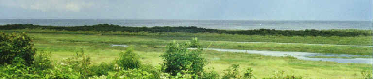
SEACROFT MARSH
Seacroft Marsh, Site of Special Scientific Interest (SSSI) & Special Area of Conservation (SAC)stretches from Lagoon Walk in the north to the boundary of the National Nature Reserve (NNR) in the South (a point just south of the end of Seacroft Esplanade). In the west from a mid point in the dunes between Lifeboat and Ocean Avenues and continuing along the edges of residents gardens (as far south as Drake Road and then fronting Seacroft Esplanade) to the mean low water mark in the east.
Until the Spring of 2015 the site consisted of a good variety of habitats with woodland and Sea Buckthorn cover, mature saltmarsh, dune systems, tidal creeks, lagoons, beach with intermittent shingle ridges and a small area of mixed rush and reed. All Sea Buckthorn and scrub habitats on the central and outer dunes were destroyed and although 10 years on there has been substantial regrowth, the destabilisation of the dune system has resulted in significant erosion to the east. It is now only a short matter of time before the outer ridge no longer holds back spring tides, thus completely changing the character of Seacroft marsh.
LOCAL NATURE RESERVE ?
Skegness should by now have a new Local Nature Reserve but East Lindsey District Council have been dragging their feet for years. At East Lindsey District Council's executive board meeting, way back in March 2004, members agreed that land at Seacroft owned by the council should be earmarked for wildlife protection, resolving that "the ‘Seacroft SSSI’, Skegness, be designated as a Local Nature Reserve". The management plan has never been finalised nor have Local Byelaws been passed, which makes the declaration as a nature reserve still a distant objective. (Executive Board Meeting 2-3-2004 item 238 Page EB200)
Skegness Standard 4March 2004 - Kevin Wilson, site manager of the Gibraltar Point reserve, said "We are very pleased East Lindsey District Council is taking this initiative to recognise the importance of an area of land it owns. This is an area which wasn't given full recognition before. There will not be major landscape changes now - far from it. We are just recognising an area which was already there."
The tapestry of dunes, pools and scrub are perfect for all kinds of wildlife - especially unusual bird migrants such as sandpipers, redstarts and warblers. The area will remain open to the public.
Mr Wilson added "We are hoping, through this initiative, to provide more information for the public through display boards and leaflets to encourage people's understanding of the area"
The decision to establish the land as a reserve would likely have spelt the end for certain recreational activities which are believed to be ecologically-detrimental - for instance, quad biking, motorcycling and illicit camping.
~~~~~~~~~~~~~~~~~~~~~~~
During December 2024 and January 2025, fencing and gates have been installed along the western boundary of the Marsh following a successful bid from East Lindsey District Council and Lincolnshire Police and Crime Commissioner through the Home Office Safer Streets Fund.
Subsequently signs were attached welcoming entrants to “Seacroft Marsh Local Nature Reserve” and interpretation Boards placed at three locations.
At present “Local Nature Reserve” is a notional title and the Statutory designation has yet to be declared and hopefully this should happen in the near future.
RANGER / WARDEN
In 2010 a Ranger/Warden position was created but only remained in position for a short while, see background.
Beach
The beach profile is constantly changing with shingle ridges regularly appearing following strong winds and these provide an ideal habitat for nesting birds in the spring. In the past a number of ringed plover nests were usually noted but were largely predated or disturbed by the public; however young chicks were subsequently seen in the area. Since 2013 very few ringed plover have been seen and very little nesting observed. Currently in 2025 the profile is steep dropping to deep water close to shore, at high tide.
At low water, a wide variety of sea birds can be seen feeding and roosting, the more regular being BlackHeaded Gull, Herring Gull, Greater and Lesser Black Backed Gulls, Oyster Catcher, Knot and Redshank. The tide wrack also forms a rich feeding ground for a variety of birds and Sanderling, Dunlin, Skylark, Shore Lark, Wheatear and Snow Bunting are seen at various times of the year.
Saltmarsh
The saltmarsh began forming some 60/70 years ago and the southern area from Drake Road to the northern boundary of the NNR can be considered as ‘mature’, the main cover being rough sea grasses with very sparse buckthorn scrub. The remaining area to the north is more dynamic as regular ingress of sand through the dune breaches has partially covered the established vegetation. Although complete tidal cover of the marsh is rare it can still occurs at the highest spring tides, sometimes to depths above 1 metre (sea water surges through the breaches in the dunes at high tide and is met by water from Greenshank Creek up to one hour later) and at other times there is spread from tidal creeks and enlargement of lagoon areas. Sand regularly deposited on the saltmarsh has blocked older creeks leaving the majority of the saltmarsh much wetter which is slowly having an effect on the vegetation.
Many interesting plants appear during the year and amongst those that catch the eye, are sea-lavenders, and sea aster: there are some species of grass on this site, which are not well represented on the NNR.
There is a network of pathways created by the public and these are broadened and kept short by the high number of rabbits. Very little damage can be attributed to foot traffic and the shorter grasses appear to allow other species of grass and plant to survive.
The marsh is an important nesting area for skylark, and meadow pipit and many pairs can be seen in the breeding season, although reed buntings have substantially reduced following removal of the Buckthorn scrub and now rarely seen in the regrowth.
Tidal Creeks
The main flow of water enters Greenshank Creek on the NNR and slowly flows up the network of smaller creeks, usually spreading as far as Drake Road, with levels peaking about I hour later than the published tide tables for Skegness. This only occurs at spring tides and on peak tides they overflow to fill the small lagoons. A new creek established opposite Derby Avenue after the 2013 surge remained open for 4 years but is now blocked by a sand bar and has filled with sand; this may change again in the near future.
Vegetation along these creeks and in some cases far wider is typical with sea-purslane, annual sea-blite, samphire and spartina.
The creeks abound with shrimps, small fish fry, larger flat fish, crabs, etc and provide important feeding for birds; small cuttlefish have been seen in Summer months. In addition to redshank, curlew, whimbrel and black headed gull, the occasional kingfisher is seen and little egrets have stayed for a number of weeks. In early summer, little terns can be seen diving into the creeks and lagoons.
Lagoons
There are a number of small lagoons, some of which dry up for several weeks in the summer. Vegetation and birds are similar to those of the creeks.
By far the largest lagoon is Seacroft Lagoon of which approximately one third is in the SSSI, the remainder being in the NNR. It is perhaps the oldest part of the site, as a continuation of the 100 year old dune ridge is on the eastern side. The lagoon now stays dry for most of the summer months but peak spring tides occasionally fill it with an average depth of some 30/40cm. At these times the number of birds feeding and roosting substantially increase.
The western edge of the lagoon runs along Seacroft Esplanade, where residents have for many years dumped their garden rubbish. There are now many garden escapees that have established themselves as a direct result of this activity together with a number of deliberate plantings by residents, presumably to enhance their view. Some of these are invasive such as Snowberry and Russian Vine and should be controlled.
On 13 February 2015 the mechanical digger moved into the slack at the northern end of the lagoon and began digging out the Buckthorn. Following completion of the work and the insertion of two pipes through the footpath, the top end of the lagoon now floods on high spring tides. Unfortunately as the land to the north of the footpath is lower than that to the south (caused by decades of accretion), sea water does not readily drain as the tide goes out and leaves an isolated saline lagoon.
This extremely aggressive approach has completely destroyed the humid dune slack and set back the maturity of the area by some 40 years.
Reed Bed
A new habitat naturally developed over a11/12 year period and although relatively small (with a spread of some 70x25 meters) had the potential to substantially increase in coming years. It is located just to the east of Drake Road access point and consists of reed (phragmites) and rush (scirpus). The area is on the edge of a tidal creek, forming a small lagoon area which tends to collect rainwater. Unfortunately since the tidal surge of 2013 the increased salinity on the marsh has caused this new habitat to decline and it will continue to be monitored.
The Buckthorn clearance also revealed a large depression in the adjoining low dune which still collects rainwater and is thought to have been the main habitat for local water shrews. Several dead water shrews (predated) have been found fairly close to this area in the past but I believe the actions carried out by Natural England have now eliminated this species locally.
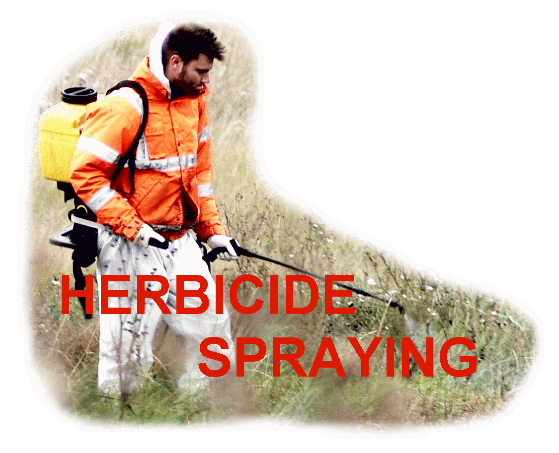
On 26th October 2015 ELDC began spraying industrial strength herbicide - find out more